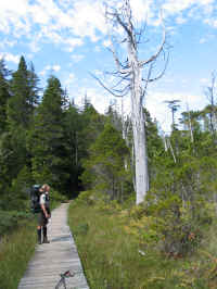
Northern Vancouver Island Trails Society
Circa 2001 - 2013

The Northern Vancouver Island Trails Society was a charitable organization founded in 2001 in Port Hardy, British Columbia, Canada. In 2004 the Society received more than a half a million dollars towards the costs of construction and enhancements to the world famous wilderness hiking Cape Scott trail system. The project expected to put Vancouver Island on the map for back country hikers and outdoor enthusiasts serving as an international and Canadian tourist attraction to the area.
This was their website for a number of years providing information about the progress of their goals and the construction and enhancements to the Cape Scott trail system. A blog was added later in 2013 to the site .
Content is from the site's 2001 - 2013 archived pages.

Northern Vancouver Island Trails Society was incorporated as a Society April 6, 2001
We are a group of volunteers interested in developing a network of trails on Northern Vancouver Island. Being a society, this development must take place without purpose of financial gain. Any profits to the society shall be used for promoting its purposes.This is where "you" come in. In order to raise funds for the particular projects such as the "North Coast Trail", we have created a Northern Vancouver Island Trails Society.
Membership is a one-time fee of $10.00 CDN payable to:
Northern Vancouver Island Trails Society
Box 526, Port Hardy BC. V0N2P0
Cape Scott Provincial Park is located on the most Northerly tip of Vancouver Island.
The trail route location was finalized and construction began in September 2004. The construction of the Cape Scott Trail is being managed by a local consulting firm, Strategic Forest Management Incorporated, out of Port McNeill, British Columbia. The trail construction is being updated on this site with Progress Reports that will be posted here for reference.
The bridge work and river crossings will be completed over the summer of 2005 with the Grand Opening of the North Coast Trail May 10,2008
North Vancouver Island Trail Offical opening May 10,2008
Cape Scott North Coast Trail Progress Report November, 2007
Cape Scott North Coast Trail Progress Report October, 2007
Cape Scott North Coast Trail Progress Report August, 2007
Cape Scott North Coast Trail Progress Report January, 2005
Cape Scott North Coast Trail Progress Report December, 2004
Cape Scott North Coast Trail Progress Report November. 2004
Trails
North Coast Trail
The Cape Scott Trail can be accessed from Port Hardy. The Holberg Road, off Hwy 19, just south of the Town of Port Hardy, is the access point for the Cape Scott Trail. A land shuttle service can be arranged from Port Hardy. www.nothcoasttrailshuttle.com
You then follow the road to the San Josef Bay parking lot where the trail begins. This trail takes you to the junction with the new North Coast Trail that continues along the northern coast of Vancouver Island, along beautiful beaches and low elevation trails through the forest. You can also arrive by water taxi from Port Hardy.
There are two different companies that service this area. 1. Cape Scott Water Taxi, 2. Catala Charters. They will bring you to Shushartie Bay entrance to the park. This route will take you along the north coast of Vancouver Island until you reach the junction with the Cape Scott Trail. The second half of this journey takes you down the Cape Scott trail until you reach the San Josef Bay parking lot. North Coast Trail Shuttle can meet you and return you to Port Hardy if you haven’t made other arrangements.
History of Cape Scott
A chance visit to Cape Scott by two halibut fishermen more than 100 years ago, who sought a goose or duck for dinner, sparked European settlements there.
Rasmus Hansen and N.P. Jensen found two streams choked with migrating salmon in 1894, and a huge area suitable for pasture, and they had visions of a Danish settlement.
Hansen returned in 1895 with three others – Peter Thomson, Nels C. Nelson and Chris Jensen – and they proposed a settlement to the BC government. They hoped to bring 15 settlers the first year and have 75 by the turn of the century.
The settlers wanted to do mixed farming and fish, and asked for a dyke at Goose Harbour to protect their fields and a road to Quatsino Sound, so they could move goods to market.
A severe storm provided a windy welcome to the first settlers in 1897, who lost their anchor and dory and piled on the rocks. Despite that, the wave of settlers continued.
Cape Scott Co-operative Store opened in 1897, with settlers buying shares for $10.
Trails were built as far as Shushartie, on the sheltered side of Vancouver Island near Port Hardy. Corduroy roads, some still existing, were used where the ground was soft and damp.
The first baby born was Bende Dorthea Rasmussen, on July 8, 1898, and the first order of school supplies arrived two weeks later. The first teacher was Carl B. Christensen, who adopted three boys so the community could have a school.
The first dyke was built in 1899, but the gates were washed out by the first high tide. The second dike was finished in 1905, and a wagon could be driven across at high tide.
The community had its first wedding in 1907 – with pictures showing Theodore Frederiksen and Johanne Jensen in front of the Danish flag, an American flag and the Union Jack – but the steamer stopped calling at Fisherman’s Bay that year.
The store closed in 1909, with goods being sold to West Arm store at what would become Holberg.
In 1913, the federal government extended its telephone-telegraph as far as Cape Scott. That same year, seven miles of promised road were built toward Fisherman’s Bay from Holberg, but it would never be finished.
The air force set up a radar station from 1942 to 1945, which closed at the end of WW II. A dozen families moved to Cape Scott to live in the barracks after that, but it was not the Utopia they thought. A great many of the airmen transferred from the air training facilities in Bend, Oregon near the Cascades mountains.
The first light at Cape Scott was an acetylene flame, replaced by battery power a few years later. The lighthouse was built in 1959. Cape Scott became a provincial park in 1973, with just over 37,000 acres included at the start.
![]()
The Tlatlasikwala First Nation, of Hope Island, and the Quatsino First Nation, of Coal Harbour, have both assisted with the trail routing study and field work. The Board of Directors of the Northern Vancouver Island Trails Society has reserved a space for each First Nation on the Board.
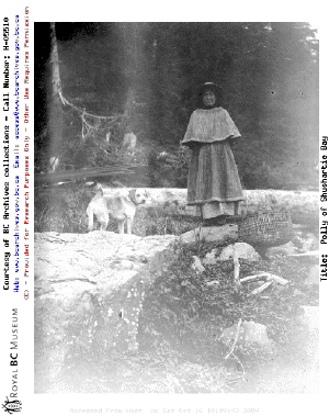
A picture of a local First Nation inhabitant at Shushartie Bay in July 1894. (Photo courtesy of BC Provincial Archives)
History of Cape Scott
by Bruce Winfield and Ruth Botel
A chance visit to Cape Scott by two halibut fishermen more than 100 years ago, who sought a goose or duck for dinner, sparked European settlements there.
Rasmus Hansen and N.P. Jensen found two streams choked with migrating salmon in 1894, and a huge area suitable for pasture, and they had visions of a Danish settlement.
Hansen returned in 1895 with three others - Peter Thomson, Nels C. Nelson and Chris Jensen - and they proposed a settlement to the BC government. They hoped to bring 15 settlers the first year and have 75 by the turn of the century.
The settlers wanted to do mixed farming and fish, and asked for a dyke at Goose Harbour to protect their fields and a road to Quatsino Sound, so they could move goods to market.
A severe storm provided a windy welcome to the first settlers in 1897, who lost their anchor and dory and piled on the rocks. Despite that, the wave of settlers continued.
Cape Scott Co-operative Store opened in 1897, with settlers buying shares for $10.
Trails were built as far as Shushartie, on the sheltered side of Vancouver Island near Port Hardy. Corduroy roads, some still existing, were used where the ground was soft and damp.
The first baby born was Bende Dorthea Rasmussen, on July 8, 1898, and the first order of school supplies arrived two weeks later. The first teacher was Carl B. Christensen, who adopted three boys so the community could have a school.
The first dyke was built in 1899, but the gates were washed out by the first high tide. The second dike was finished in 1905, and a wagon could be driven across at high tide.
The community had its first wedding in 1907 - with pictures showing Theodore Frederiksen and Johanne Jensen in front of the Danish flag, an American flag and the Union Jack - but the steamer stopped calling at Fisherman's Bay that year.
The store closed in 1909, with goods being sold to West Arm store at what would become Holberg.
In 1913, the federal government extended its telephone-telegraph as far as Cape Scott. That same year, seven miles of promised road were built toward Fisherman's Bay from Holberg, but it would never be finished.
The air force set up a radar station from 1942 to 1945, which closed at the end of WW II. A dozen families moved to Cape Scott to live in the barracks after that, but it was not the Utopia they thought.
The first light at Cape Scott was an acetylene flame, replaced by battery power a few years later. The lighthouse was built in 1959. Cape Scott became a provincial park in 1973, with just over 37,000 acres included at the start.
EARLY SETTLERS
The first settlers paid $50.00 per family for a bond which was to pay their transportation to the colony. Many colonists, some with families arrived in 1897. More followed in the next year. There was a pooling of labour, each helping others ...locating properties and helping with erection of homes.
1897 - mid June - a group of fourteen men travelled to River's Inlet from Cape Scott in hopes of making some money from fishing, the year of 1897 was a poor season.
1897 - the store (and it later contained the post office) was built at Fisherman's Bay. Nels C. Hanson was the manager of the Cape Scott Co-operative Store, he was nicknamed "the grocer". The Cape Scott settlers bought shares at $10.00 a share.... this investment helped the store get started. The first order of supplies arrived July 5th 1897 - among the supplies was: 2 sacks rolled oats, 1 sack beans, 5 sacks potatoes, 1 case of lard, 1 case Reindeer (brand name?) milk, 1 box Evap. apples, 1 case tomatoes, 1 box Evap. prunes, 25 pounds currents, 1 sack salt, 25 Ibs. whole roast coffee, 2 boxes Tea - 35 Ibs., Spices, 30 Ibs. sago, 1 sack Japanese rice, 1 tub creamery butter - 25 Ibs., 1 cheese - 17 Ibs., 1/2 case roast mutton -30 cans, 1 case roast beef- 30 cans, 1 case coal oil - 35 gal., 1 box anchor soap - 3 doz., 1 (?) eagle soap -30 bars, 1 box Baking powder - 1 doz., Royal yeast cakes - 2 doz., 10 plugs P. W. tobacco, 10 plugs P .B. tobacco there were many other items including clothing in the order. There was
a second grocery order for the same date. The next orders arrived on Aug. 9th and 3 Oth and regularly after that.
The trails were constantly worked on. Sometimes with govemment pay,other times for nothing. Cordoroy was used where the ground was soft or damp. The trail to Fisherman's Bay was wide enough for a wagon and from that trail to the dyke was as wide. The other trails were improved as time allowed. Some of these trails were originally made by the Native people.
1898 in the early spring, Carl Rasmussen travelled to Victoria and purchased a sawmill. The boiler from this mill sat at the side of Fisherman's River on the raised bed of stones until the late 1960's when the river, during a storm, corroded the bank and the boiler tumbled in. Some historians have imagined that this boiler was used by N.P .J ensen for his milk condensory N. P. never had a milk condensory! Carl with the help of his brother-in-law, Theo Frederiksen, cut needed lumber for the settlers in hopes of pay after the fishing season.
July 8th 1898 - the first baby born to the new settlement was Bende Dorthea Rasmussen.
1898 - July 26th - the first order for school supplies arrived. Included in the order were readers, spellers, reading charts, copy books, Lowells geography books, 1 atlas, grammar books, 30 slates, 1 box slate pencils, 2 doz. lead pencils, 2 doz, pen holders, 1 box pen nibs, erasers, ink, chalk another order of school supplies arrived in Oct. Carl B. Christensen was the first school teacher ...nicknamed "Professor Christensen". He adopted 3 boys to bring the school population up to the required level.
1898 - The population of the colony was listed as aprox. 90.
1899 - The first dyke was completed, immediately the flood gates were put in. That evening, in celebration of the completion, the settlers gathered for a well earned party which lasted through the night. A strong southeast storm came up during the night and took the gates out along with a big chunk of dyke. One theory was that the gates were put up too early before the dyke had properly settled -the dyke was not yet strong enough to withstand the weight of the water.
1901 - the Canadian Cenus gave a population of 65 for Cape Scott.
1901 - the settlement launched the "Cape Scott" built by Rasmus Hansen with the help of other settlers. The boat carried supplies and passengers from Sea Otter Cove, San Josef Bay and Strandby-places not served by the Steamer.
1903 - one of Professor' Christensen's boys died of blood pOisonIng.
1905 - the second dyke was completed - at high tide a wagon could be drive over across the top. All the settlers worked building the dykes, N.P. Jensen was the driving force and was there almost every day working with whoever else had time.
1905 - Harry Shuttleworth (later settler of Strandby) did placer mining on Gold Beach at Nahwitti with Jeptha Skinner. Shuttleworth apparently did take aprox. $1200. in gold from the east side of Gold Beach a previous year.
1907 - The first wedding of the settlement took place - Theodore Frederiksen married Johanne, the daughter of N.P Jensen and his wife, Maren. The photo of the happy couple show them standing in front of three flags stretched out - the Union Jack, the American stars and stripes and the Danish flag.
1907 - the steamer stopped calling at Fisherman's Bay. The colony slowly dribbled away.
1908 - Dec. - a hurricane levelled patches of timber all over the North Island. Eight years later, a government surveyor said that there were windfalls criss-crossed to depths of 25 ft in many places.
1909 - The store was closed and Nels C. Nelson moved some store belongings to the West Arm Store with the shareholder's approval and helped set up the store in what was to become Holberg. The shareholders were given their share of cash. Many of the Cape Scott settlers had moved to the West Arm and some of the others to Sea Otter Cove and San Josef Bay.
1910 - The Cape Scott sank due to an unexpected storm coming up during a trip to Quatsino. N. P. Jensen's son, Lars and his adopted crippled son, Miles died.
1910 - The first post office opened in Shushartie Bay with Mr. Skinner as the postmaster. Over the years there were several other postmasters, it closed finally on Sept. 2, 1952. There was a steamboat landing at the Bay. James Wallace ran the General Store.
1911 - Strandby opened their post office on March 1, 1911, David Patterson was the postmaster. This post office closed in 1917 when John Lockwood resigned his position as postmaster. It must have reopened later as I have a postcard stamped by the Strandby post office on August 12, 1930.
1911 - The "Cape Scott 11" was built in Vancouver with financial help from many of the settlers. Capt. HenrY Petersen skippered this boat till he died in 1924 except for a short period in 1913 when Walter Petersen took over, Walter drowned in Quatsino during Dec. of the same year.
More people settled in the Cape Scott area. Charles Wadey, a professional gardener arrived in 1912. He organized an exhibition of vegetables and fruits at the Cape Scott Community Hall/school building in 1914. Two hundred people attended.
1913 - Nahwitti opened a post office, Frank Bragg was the postmaster. The post office closed on August 25, 1918 - Clarice Hole was the postmaster at this time.
1913- The Dominion Government extended the telephone/telegraph system from Port Hardy to Coal Harbour. The line ran from there up the West Arm to Holberg and then to Cape Scott and Sea Otter Cove by way of San Josef, carried along in the trees on the old trail. This service was mainly found in the post offices along the way. (1 private home at Cape Scott, had the service).
The Trails - according to an oldtimer - From Fisherman's Bay to the Lagoon (and as far as Donaldson's) ...also to the Sandneck- the trail was wide enough for a buggy or wagon to travel. The section right at the Sandneck went along the upper part of the beach and during the extreme high tides of winter this part couldn't be used. The rest of the trails to Strandby, to Nahwitti and Shushartie, and around Hansen's Lagoon were 3ft to 4 ft wide and was only suitable for walking or using a horse.
1913 - A wharf had been built in Holberg extending 1/2 a mile. There were 7 miles of road stretching towards Fisherman's Bay. Several of the settlers went off to war and some did not return after the war.
1914 - The Goletas Fish Co. Ltd. started a cannery in Shushartie Bay and in 1917 the cannery was taken over by Western Packers.
1915 -There was a school at Strandby...Lumber, mining, fishing and farming were the main occupations of the residents. They had weekly mails and a General Store. Their population aprox. 40 to 45. (Matte Shuttleworth (nee Christensen) named Strandby after her town in Denmark.)
1915 - Soren Christensen...first settler of the Strandby area, died January 22 and was buried on Soren Hill.
Archie Darlington had set up a store in the old Co-op Store building, he enlisted and the Vicks family were running the store 911 in 1916.
1918/20 - Nahwitti had a population of 25. several men in the community were involved in mining or prospecting. Others were farming or fishing. Nahwitti and Strandby had formed a Farmer's Institute with Albert Higgins the: secretary. Albert Hole was a lineman, assistant postmaster and a member of the Farmer's Institute. Three other Hole brothers were involved in mining. A Telephone Office was located in the settlement and people travelling used a launch to reach Shushartie where they would board the Union Steamship.
1918 - The B.C. Directory has the pop. of Cape Scott listed as 150 with fishing, famling and logging as the main employment.
1919 - The population in Shushartie was 25, this increased during the Canning season with fishermen and cannery employees. G. Darlington ran the General Store. J. Skinner was the postmaster and owner of a General Store. Goletas Fish Company Ltd and Western Packers Ltd operated during the fishing season.
1923- Canadian Fish Co. Ltd. bought the Cannery at Shushartie Bay, ran it there for a few years and then in 1928 dismantled the cannery and moved it to Cracroft Island.
1925 -Jack Wilder died and in 1928 his partner James Madigan died, the two men owned a lot of pasture at the dyke and they were the ones who built the large barn. The pasture and barn were bought by Alfred Spencer.
1927 -The government installed an unwatched automatic acetylene light at Cape Scott on the Theodore Frederiksen property. A few years later a battery operated light was installed by
the government.
1934 - N.P. Jensen, one of the first settlers in the community died Nov. 27...A gravestone marks his grave at the Sandneck. Some of the Lightkeepers have worked at keeping the grave site in neat order. This was the man who worked so hard at the dykes and the man who build the heavy driftwood fence at the Sandneck.
1937 - March 14, Johanne (Hannah) Frederiksen died (daughter of N. P. Jensen) and buried at Alert Bay. Her whole life since a young girl had been spent at Cape Scott.
1939 - Hans and Lars Frederiksen Drowned while crossing to the Scott Islands on their boat "the Barnacle" in early Feb. (sons of Johanne and Theodore). An unexpected storm came up quickly.
1942 - The Canadian Gov't along with the Americans decided that the Sandneck at the Cape would be an excellent place to place a radar station. The Frederiksens were given notice that their land - 2 quarter sections at the Sandneck were being expropriated and the gov't would move them out. The airforce arrived in early summer. One person moved into the house with the Frederiksens, and the others camped in tents in the pasture. Theodore was very upset with it all. They were quite restricted on where they could walk. The family left in November, moving to Nanoose Bay. At this time Pete and Elsie Hersley and children, Alfred Spencer - Postmaster and keeper of the Cape Scott library, Dorothy and Billy Gibbs and the Donaldsons still lived in the lower area of the settlement. This radar station was disbanded on June 19, 1945.
There was a brief bit of activity following the closing of the military base. The plan was to use the Airforce buildings and the gov't had agreed to helping with the construction of a breakwater. Twelve families arrived but soon left, disillusioned by what they found, not quite the utopia they'd hoped for.
1959/60 - A lighthouse was erected at Cape Scott. The materials for the building was brought in by Carl Botel with his boat the "Cliff Point" and his boat stayed anchored at the Lagoon, Carl cooked for the workers and the spent the nights on the boat. The first lightkeepers were the Gardners.
1962 - Theodore Frederiksen died, his ashes were buried under the old rhododendrum beside their house on the North end of the Sandneck. Later one of the lighthouse keepers, unknowning it marked a grave, moved the rhodo to the lighthouse. Theodore helped with the sawmill and the building of the first "Cape Scott". He taught his children music, made two violins out of wood from the Cape and built numerous small boats.
The last trap lines in the Cape Scott area were let go in the 1960's - Lyle McRae had held the Guise bay, around the Cape to Shuttleworth Bight and Carl Botel was the last person to hold the trap line which started at Guise Bay running South down the coast to the Lagoon and around it and the proceeding to the south end of Lowrie Bay.
1973 - Cape Scott Park was established and was composed of 37,239 acres of land. More area was added in 1995 giving the Park a total of 54, 907 acres in all.
1988 - During August Violet Wamer's (nee Wadey) ashes were packed in by her family and scattered on the beach at Guise Bay where Violet and her husband built their home.
BLOG POSTS
A Fundraising Event for The Trail Society
Port Hardy
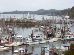
Due to the declining membership of the Trail Society over the last couple of years, we have decided to try to raise awareness and funding by putting on an event in the local community. We’ll be hosting an event in Port Hardy. We are grateful for the use of the local chamber facilities to hold this event.
Dates and Times
The fundraising event will be held on Saturday, June 27 2015. The event will start at 7:00 PM. We’re hoping to arrange for a popular local band to play the event. We won’t be disclosing the name of this band until they have confirmed that the date is open in their schedule.
You can get directions to the event from the Port Hardy Chamber website. We will be utilizing their facility to hold the event. Tickets will go on sale May 1, 2015 for $100 each. All of the money will be donated to the Trail Society to help us boost membership and maintain the trails which are the reason for this great organization.
More About The Society
The Northern Vancouver Island Trails Society is a group of volunteers that has been organized to spearhead trail projects on Northern Vancouver Island. This group of volunteers became incorporated as a Society April 6, 2001. Our first major project, the current focus, is the North Coast Trail. The North Coast Trail will provide over 47 kilometres of spectacular world class walks, trails and campsites in a remote wilderness setting. The trail will link with the existing Cape Scott Trail to further enhance the hiking opportunities and adventures to be found on the North Island.
Membership
As a non-profit Society, the development of trails must take place without any purpose of financial gain. Any profits to the Society shall be used for promoting its purposes.Membership to the Northern Vancouver Island Trails Society is available. Please fill out the Membership Application and Donation Form (link below) to be involved and to support the development of the North Coast Trail. Individual membership is available for $15.00 Cdn, Family membership $25.00 Cdn and Groups (organizations, companies, corporations) are available for $100.00 To download your form Click Here
If you do not wish to join as a member but would like to donate to support the trail society, the above form can also be used.
You too can become a North Coast Trail Sponsor with your tax deductible donation. A Sponsorship Form is provided below for you to become a recognized sponsor with your donation in one of three categories, bronze, silver, or gold. With your contribution of over $5,000 you will receive special recognition on the Society’s web site, recognition at public events and on all advertising for the North Coast Trail. If you wish to sponsor a specified component of the trail (e.g. bridge, camp facility, etc), special recognition will be placed at that location.
Sponsors at the Event
While we haven’t worked out all of the details, we do know that we’ll be serving small batch ice cream from Bonta Gelato in Bend Oregon. They have agreed to donate all of the profits from the even to the Trail Society. For those not familiar, they are a small ice cream company from Oregon that uses Northwest ingredients to make truly delicious gelato. Check out their Yelp.com page for more information.
Other sponsors are in the works as well as food carts and catering. We hope to raise $10,000 for the Trail Society so get the word out to all of your friends and family.
This entry was posted on April 23, 2015.
Finding a Good Gym in Central Oregon
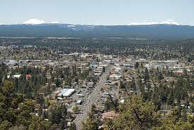
Central Oregon is one of the best places in the country in which to live if you enjoy the outdoors. The city is full of people that are in incredibly good shape. And there are host of fitness clubs and gyms in the area from which to choose when you can’t get outside for your exercise.
Bend Oregon
Bend is a town of about 85,000 people. Most folks move to Bend to be near the mountains. There’s great skiing in the winter and incredible mountain biking in the summer and fall. But sometimes the weather can get pretty nasty. On those days it makes sense to stay indoors to get your exercise. Bend Oregon gyms offer a great alternative to outdoor exercise. And there are quite a few to choose from.
One of the nicer ones is the Bend Downtown Athletic Club. It is run by Gary and his wife Laura. One of the best things about this particular facility is that is almost never crowded. There are very few times when you’ll actually have to wait to use a machine or weight bench. There’s a sign up sheet on the wall for the cardio machines, but most times it’s not even necessary.
The entire gym is kept immaculately clean at all times. The staff makes sure that all weights are returned to their rightful place repeatedly throughout the day. This means that you never have to go searching around the gym for a particular piece of equipment.
There are various classes throughout the week. They have a spin class, and a weightlifting cardio type class two days per week.
If you are interested in working one on one with an expert, they have several certified personal trainers on staff to help you put together a fitness plan. They can even help you with diet and nutrition plans as well.
Overall the Downtown athletic club is a top notch facility.
This entry was posted on May 19, 2014.
Paleo Cookies Make Great Trail Food
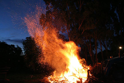
The proliferation of meal replacement bars, camping food, and other packaged meal products in recent years gives hikers and backpackers more options than they’ve ever had before. Products range from the ubiquitous protein bar to dehydrated food of practically any sort. Let’s take a look at some of the foods that are best suited for a both a day trip hike or a longer trek in to the wilderness.
Dehydrated Foods
If you’ve been in an REI in the last few years you’ve probably seen the amazing assortment of dehydrated foods they now carry. As crazy as it may sound, you can have anything from roast beef to a bowl of pasta by simply adding a bit of boiling water to these products. One of the more popular brands is Mountain House.
Mountain House was originally incorporated in 1963 as Oregon Freeze Dry. They started out freeze drying fruit for General Mills cereals. They then became involved in improving rations for the military. Shortly thereafter they began producing their own product. And let me tell you, their selection is completely astounding.
Since everything is dehydrated, the weight of the product is reduced significantly. All of them come in pouches or cans and are extremely easy to pack. The only downside is that they tend to be a bit expensive, so it can feel like a week in the woods takes a significant chunk out of your salary. But when compared to a prepared meal out, it’s relatively inexpensive.
Higher Fat Foods
Fat is the most efficient form of energy. And while most of us think of carbohydrates when we want to replenish our bodies energy levels, fat actually contains more than twice as much energy as carbohydrates. Carbohydrates are great for short intense exercises, but our bodies were designed to use fat for more prolonged activities such as hiking.
It makes sense if you think about it for a minute. Our muscles can hold only a very small amount of glycogen (what our bodies produce from carbohydrates). However, unfortunately, we have an almost unlimited capacity to store fat. This is because our bodies know that we will then have a fuel source should our regular food supply run out.
So foods that are higher in fat are a great choice for going on a hike. This is nothing new. Fur trappers and explorers utilized pemmican all of the time when they traveled. It was a mix of dehydrated meat, dried fruits, salt and other herbs, and loads of cooked animal fat. Some early explorers literally survived on this and very little else.
Now days you can find things that might sound a bit more appetizing. The Paleo diet professes a higher intake of fat, and several products developed for that lifestyle are great for hiking. There are pemmican products that are made for modern palates. There are also gluten free desserts such as cookies and desserts that are lower in carbs and higher in fats than traditional products. A good assortment of paleo cookies can be found here on Amazon.com. They are also available at www.gourmet-paleo.com. You can even find their gourmet paleo chocolate chip cookies on Etsy.
Standard Dried Foods
Last but not least are the old fall backs. Dried foods have been around for thousands of years and for good reason. They’re a great source of protein and carbohydrates. While they shouldn’t make up your entire diet while hiking, they are great ways to recharge while on the trail. Beef jerky and dried fruit are some of the most popular. Since it’s dried, these foods take up much less space. It can be tough to travel with a bag full of apples. But a bag full of dried apples, bananas, or peaches are healthy, lightweight, and don’t take up much room in your pack.
Whatever you decide to take with you into the woods, just be sure that it can be sealed airtight so that it doesn’t attract animals. And as always when camping store your food in a safe location away from your campsite. If you do have a bear come to your campsite you want them going after your food, not you.
This entry was posted on March 9, 2014.
Minimalist Hiking Shoes, a Must Have for Serious Hikers
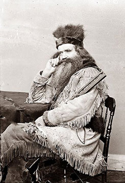
One of the best part of being in the great outdoors is the connection with nature. In a previous post we discussed the health benefits associated with spending time in nature as well as some of the essential gear to carry.
Today we’re going to talk about some other must have gear. A great set of minimalist hiking shoes. Hiking shoes have been around forever. The trappers devised their own shoes for their journey deep in to the wilderness in search of beaver and other pelts. These were often simple moccasins with little protection from the elements.
However, they did provide these pioneers with a very accurate connection to the ground. What do we mean by this?
Most of today’s shoes offer a great deal of cushion. This is done to make the shoes as comfortable as possible. However it also disconnects us from the ground. It also has the adverse effect of raising our entire foot higher off the ground, making injuries such as a sprained ankle more likely.
Moccasins on the other hand provided a small layer of protection, and a great connection to the ground. This makes walking in more treacherous terrains much easier. Of course, in moccasins you have to watch out for sharp rocks and other objects since they didn’t offer a great deal of impact protection.
Now days however, that is not the case. There are several manufacturers of shoes that are considered minimalist shoes. This means there is as little as possible between your foot and the ground. Most of the shoes in this category have a thin layer of cushion or none at all. They do incorporate a sole that is made of very tough and durable material that is designed to protect the foot from sharp objects.
One company that has been making minimalist shoes for years now is Inov-8. They have a whole line of lightweight hiking shoes that are perfect for your next outdoor excursion.
So how does this help you when you’re on the trail? Simple. When you walk in a minimalist shoe, you can feel everything that’s going on between you and the ground. If one part of your shoe starts to slip, you can immediately feel it and correct for it. In addition, your heel is closer to the ground. This means that even if you did roll your ankle, you have no distance to travel. It is actually pretty difficult to roll your ankle in a good pair of minimalist hiking shoes.
Another great benefit is that they are extremely lightweight. Some minimalist shoes weigh in at under 8oz per shoe. This means you won’t wear yourself out trudging in a heavy pair of hiking boots. You will feel the impact in your thighs and your hip flexors.
The only drawback to minimalist shoes is that they’re not really made for cold weather conditions. If you’re going to be hiking in areas with snow and ice, you’ll want a warmer option. But they’re so small and light, that you can easily pack them on any trip.
For more information on minimalist shoes, shoes for CrossFit, and other specialty shoes check out this webesite. At Efficient Gains you’ll find lots of great information on exercise gear and outdoor equipment.
This entry was posted on December 9, 2013.
Equipment You’ll Want to Have on the Trail
There’s nothing quite like getting out into the woods and reconnecting with Mother Nature. So much of our lives are now spent indoors that we often forget how much we need to be outside, in the fresh air. While you may not consider it equipment, a warm jacket is essential to both comfort and survival in a cold environment. We love our North Face Osito Fleece Jackets for this reason, preferably with a hood. North Face makes a number of superior outerwear ideal for this kind of outdoor activity. Make sure you also have a pair of waterproof gloves or mittens and if your jacket does not have a hood, you should wear or carry a hat that can cover your ears.
Getting into the woods allows us to clear our minds and get back to our instinctual roots. Not only is it good for us, but we need it. At Marksdailyapple.com, Mark Sisson goes into a number of reasons why it’s good for us to get out. Here are a couple of his articles.
Shake Your Gym Addiction, The Outside World is Waiting for You
The Health Benefit of Nature
He even talks about How To Work Outside.
But one thing to keep in mind is that nature has it’s dangers as well. And there are few things that you can take with you to protect yourself while in the woods.
Bear Spray
While it is unusual to run into bears in the wild, it can be a terrifying experience. A friend of mine was recently walking along a fairly busy path and came face to face with a male brown bear. Luckily he was downwind, and the bear never even noticed he was there. But he estimates he was only about 3o feet from this 500 pound behemoth.
Bear spray is a great way to protect yourself during an attack. But be aware of a couple things:
1. When you need bear spray, you need it FAST. DO NOT store bear spray in your backpack. By the time you get it out, it will be too late.
2. Bear spray becomes less effective in rain and windy conditions. Use common sense and be very aware during these types of conditions.
3. Attacks rarely occur from the front. They often come from the side, or worse, from the rear. Always have your spray in an easy to access place.
Life Straw
Taking plenty of water with you on a hike is common sense. But anything can happen when you are deep in the wilderness. The human body can survive for well over a week with no food, but without water, you can die in 36 hours under the wrong conditions.
Life straw is a device that allows you to drink out of practically any water source without having to worry about parasites. It works just like a straw, you simply place one end in the water source, and draw water through the microscopic filters. You can get clean water from a mud puddle with this gear.
Survival Knife
A survival knife is a great tool to have with you when out in the woods. Knives can be used for any number of things, and can be a life-saver in certain conditions. Always make sure that your knife is properly maintained. Carrying a small knife sharpener is a good idea as well. Heavy usage can cause a blade to become quickly dulled.
There are literally hundreds of survival knives on the market. For a great list, check out the BestSurvivalKnifeGuide.com. Here you’ll find reviews on knives ranging from $25 to $500. Some even come with a magnesium strike so that you can light a fire when necessary.
This entry was posted on October 5, 2013.
A Visit to Cascades Lakes in Central Oregon
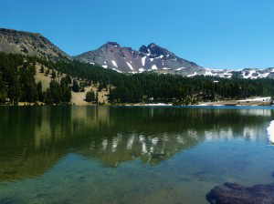
While we always delight in the hiking in and around Vancouver Island, it is often nice to get out and see new places. Recently we had the opportunity to travel to Central Oregon and explore one of the most beautiful wilderness areas in the U.S.
The Cascade Lakes area is located east of Bend, Oregon. Bend is most famous as the home of Mt. Bachelor, one of the premier skiing and snowboarding mountains in the Northwest. Bend is best accessed by car if you live in the Northwest, and via Redmond Airport if you live more than 5 hours away. Redmond is about 12 miles from downtown Bend, so the trip is quite easy.
Once you’re in Bend, you simply follow the Cascade Lakes Scenic Highway to the west out of town. From here you can explore any number of trails.
One of the most popular hikes is the South Sister. which rises to a height of 10,358 feet. It is the tallest of the Three Sisters mountains, and also the easiest to summit. The trail to the top is actually quite reasonable with the exception of the last 1000 feet. This part of the trail is made up entirely of volcanic scree. For every step up you take, you’ll slide back down a half step. Both the Green Lake and Devil’s Lake trailheads will allow you to reach the summit of the South Sister.
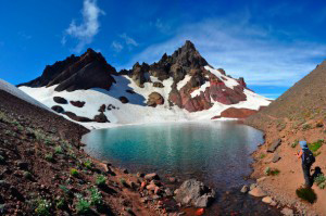
Broken Top mountain is another popular hike that can be accessed from this area. Broken top offers both great hiking and novice climbing. No ropes are required unless you want to get to the very top. Broken top an be accessed from the Green Lakes trailhead.
While there are dozens of lakes spread throughout the Three Sisters Wilderness, if you follow the Cascades Lake Highway further south, you’ll find even more lakes. One of the most scenic is Waldo lake. From the Cascades Highway you can either take an extremely bumpy fire road (which is what we did) or you can drive further south and then loop back north to the lake on all paved roads.
Either way, the lake is worth the trip. There is plenty of camping on both the north and south side of the lake. Just be aware that in the early summertime mosquitos can pretty bad, especially at the south end of the lake.
All of these areas are within the Deschutes National forest. You can find more information on hiking, climbing, camping, and other outdoor activities at their website.

